| Indicator | Value |
|---|---|
| ISO 3166 alpha-2 | KIISO 3166 [2024] |
| ISO 3166 alpha-3 | KIRISO 3166 [2024] |
| Capital | TarawaGeoNames [2024] |
| Continent | OceaniaGeoNames [2024] |
| Common name | KiribatiCIA World Factbook [2025] · 2026 archive |
| Official name | Republic of KiribatiCIA World Factbook [2025] · 2026 archive |
| Local name | KiribatiCIA World Factbook [2025] · 2026 archive |
| Etymology | the name is the local pronunciation of "Gilbert," the former designation of the islands; originally named after explorer Thomas GILBERT, who mapped many of the islands in 1788CIA World Factbook [2025] · 2026 archive |
| Government type | Presidential republicCIA World Factbook [2025] · 2026 archive |
| Independence | 12 July 1979 (from the UK)CIA World Factbook [2025] · 2026 archive |
| National holiday | Independence Day, 12 July (1979)CIA World Factbook [2025] · 2026 archive |
| Head of state | Taneti MAAMAU (Pres.)CIA World Leaders [2025] |
| Currency code (ISO 4217) | AUDISO 4217 Currency Codes [2026] |
| Currency | Australian DollarISO 4217 Currency Codes [2026] |
| Administrative subdivisions | 3ISO 3166-2 Subdivisions [2026] |
| Subdivision names | Gilbert Islands / Line Islands / Phoenix IslandsISO 3166-2 Subdivisions [2026] |
| Historical overview | No authoritative open source found |
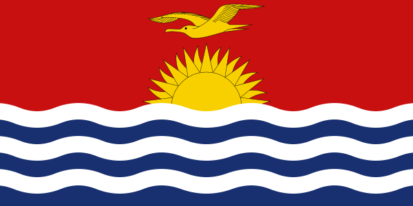
| National symbols | frigatebirdCIA World Factbook [2025] · 2026 archive |
| National anthem | title: "Teirake kaini Kiribati" (Stand Up, Kiribati); lyrics/music: Urium Tamuera IOTEBA; history: adopted 1979CIA World Factbook [2025] · 2026 archive |
| National colors | red, white, blue, yellowCIA World Factbook [2025] · 2026 archive |
| Citizenship rules | citizenship by birth: no; citizenship by descent only: at least one parent must be a native-born citizen of Kiribati; dual citizenship recognized: no; residency requirement for naturalization: 7 yearsCIA World Factbook [2025] · 2026 archive |
the name is the local pronunciation of "Gilbert," the former designation of the islands; originally named after explorer Thomas GILBERT, who mapped many of the islands in 1788
description: the upper half is red with a yellow frigatebird flying over a yellow rising sun, and the lower half is blue with three wavy horizontal white stripes to represent the Pacific Ocean meaning: the white stripes represent the Gilbert, Line, and Phoenix island groups; the 17 rays of the sun represent the 16 Gilbert Islands and Banaba (formerly Ocean Island); the frigatebird symbolizes authority and freedom
Source: CIA World Factbook (Historical Archive — final edition) · CC0 · Edition 2026-05